
Return to North Glen or Reading List or Credo
Don't go around saying the world owes you a living.
The world owes you
nothing. It was here first.
-- Mark Twain
The place we now know as Taliesin, the "homeplace" of Southwest Community Woodlands Trust, has of course been around a lot longer than we have. We only began in 1997, but we can celebrate our 21st Birthday in style!
This is a good point at which to note that I am not at all expert in these matters, and would be very happy to be corrected and to learn more from anyone. A brief article on landscape formation in Scotland from Scottish Natural Heritage may help for those wishing to delve a bit deeper.
Taliesin lies between Screel and Potterland hills, both of which are
composed of the Older Silurian rock which dominates Galloway. These hills appear to have been
pushed up by the granitic intrusion which extends from Bengairn to Criffel. Immediately to
the South of these hills, the granite appears as outcrops and peninsular landforms.
"The granite masses rose into position in a state of fusion, intensely hot, and the rocks in contact with the granite were profoundly altered and re-crystallized.... The granite never reached the surface, but consolidated under a great overlying mass of rock, which has now been swept away." Learmonth p33
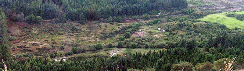
Taliesin itself appears to be largely composed of glacial rubble carried down by the ice and meltwater and deposited where the valley narrows and may contain a rock dam virtually bridging the gap. The ice was probably a mile thick at the peak of the last glaciation. Taliesin straddles part of the space between these two hills, and without doubt the present meadow areas were continuously flowing with meltwater as the ice retreated some ten thousand years or so ago.
 During the glacial period Galloway was buried under a
deep layer of ice. Great masses of snow accumulated
on the high hills and formed a moving ice-sheet, which
streamed southwards into the Solway, carrying with it
numerous blocks of rock, which were deposited along
its course. Blocks of Criffel granite are found near
Birmingham and in South Wales."
(Learmonth pp34)
During the glacial period Galloway was buried under a
deep layer of ice. Great masses of snow accumulated
on the high hills and formed a moving ice-sheet, which
streamed southwards into the Solway, carrying with it
numerous blocks of rock, which were deposited along
its course. Blocks of Criffel granite are found near
Birmingham and in South Wales."
(Learmonth pp34)
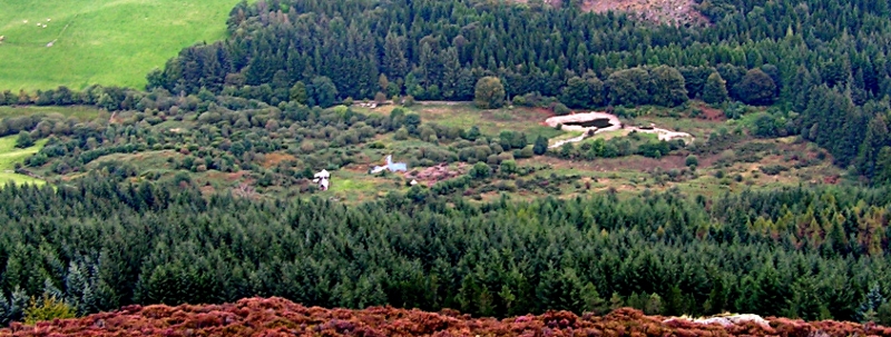
To this day, all the water which falls in the catchment above passes through Taliesin. Because of this and the relatively small area of the catchment (less than 1000 acres), water levels and flow vary considerably depending upon recent rainfall. From the excavations we've engaged in, the lower areas are roughly stratified, with about 30cm of topsoil overlaying a layer of largish sharp stones and gravel in sandy clay, and below that occasional very large stones and finer clay.
At the upper end of the valley and Southwestward along the upland areas towards Kirkcudbright as well as to the East, there are numerous ancient hill fort and settlement remains. It doesn't seem that Taliesin has ever been cultivated or put to any significant use beyond livestock grazing, and is thus endowed with most of its natural biodiversity. No maps show any symbols indicating domestic buildings, with the posible exception of the un-named enclosure at the eastern corner. Local elders tell me that the area was known as "the muir" or moor - effectively 'waste' ground.
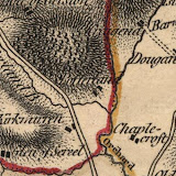
") The earliest maps I've been able to find are neither very detailled nor accurate
until a 1797 Map of the Stewartry of Kirkcudbright published by John Ainslie - Zoomable, thanks to the National Library of Scotland),
which shows Potterland Hill as forested, probably with hazel coppice and oak standards
at a guess. The nearby hills are not shown as wooded, there are woods shown in
several lower places nearby, notably Barrhill, Bankend, Orchardton, Torr Point,
Kirkennan and Munches.
The earliest maps I've been able to find are neither very detailled nor accurate
until a 1797 Map of the Stewartry of Kirkcudbright published by John Ainslie - Zoomable, thanks to the National Library of Scotland),
which shows Potterland Hill as forested, probably with hazel coppice and oak standards
at a guess. The nearby hills are not shown as wooded, there are woods shown in
several lower places nearby, notably Barrhill, Bankend, Orchardton, Torr Point,
Kirkennan and Munches.
Succeding maps show these wooded areas persisting with
little change right up to the present day.
 A mill pond is shown on the 1847 map, together with diversion of the burn along the contour to feed it. The wet centre persists in the woods below Taliesin, and the location of the (probably sluice-gated) outlet, but little other sign of any works. The burn was probably straightened from where the track crosses its bridge to somewhere beyond the diversion out-take, and this may explain the tendency of the path along it to get boggy as the straightening works may be leaking into older pathways. The route of the diversion can be traced among the hawthorns which now thrive on both sides of the remaining channel.
The track from the road up to the present forestry track has clearly been made, bridged, and culverted since at least the 1850s, and was only inundated in the mid 1990s by the pond near the cabins. There is now little sign of where the track is shown to have continued onto the lower slopes of Screel.
A number of maps show an un-named enclosure in the eastern corner which is now infested with
Japanese knotweed and also contains some (20th century?) tipped domestic rubbish. Both the rubbish and knotweed may originate in the roadside corner on the FC side, where there is evidence of fly-tipping. The high ground at the upper end of Taliesin is shown as wooded on the 1847-50 map, and drystane dyke remains confirm its enclosure, but the woods along the foot of Screel to the south and west of Taliesin don't appear until the 1895 maps, though the 1847 six-inch map shows this area tending towards trees (probably naturally). Aside from these, it seems that very little additional land in the area became woodland before the eatablishment of the Forestry Commission following the first World War. Potterland wood was acquired by the Commission in the early 1920s.
 In 1905 Kirkcudbrightshire had 19,708 acres in woods
and plantations, or roughly 1/30th of the area, but at one
time the greater part of the county was covered with
wood, largely oak. This is shown by place names,
remains of natural timber on the sides of hills and banks
of rivers, and by the numerous peat mosses out of which
trunks of trees are still dug in good preservation.
(Learmonth pp38/9)
In 1905 Kirkcudbrightshire had 19,708 acres in woods
and plantations, or roughly 1/30th of the area, but at one
time the greater part of the county was covered with
wood, largely oak. This is shown by place names,
remains of natural timber on the sides of hills and banks
of rivers, and by the numerous peat mosses out of which
trunks of trees are still dug in good preservation.
(Learmonth pp38/9)
 During the War, the Canadian Forestry Corps
logged the woods at Potterland, and were said to have lived in "log cabins" somewhere in the
immediate area. There was also probably a sawmill, but I haven't been able (so far) to learn
its exact location. (I have since been told that the log cabin camp was probably in the "Hole of Gelston".) A pond and (corn) mill is shown at Potterland on most maps,
and probably the camp and sawmill were close by, as an appropriate "landing" area connected
to good roads for onward transport... The 1847, 1895 and 1902 maps all show timber trails
converging on the farmstead area.
During the War, the Canadian Forestry Corps
logged the woods at Potterland, and were said to have lived in "log cabins" somewhere in the
immediate area. There was also probably a sawmill, but I haven't been able (so far) to learn
its exact location. (I have since been told that the log cabin camp was probably in the "Hole of Gelston".) A pond and (corn) mill is shown at Potterland on most maps,
and probably the camp and sawmill were close by, as an appropriate "landing" area connected
to good roads for onward transport... The 1847, 1895 and 1902 maps all show timber trails
converging on the farmstead area.
Interestingly, on the Ainslie map and at least one other, the hollow in the hills above Gelston Lodge is named as 'Hole of Gelston'. There is no sign of any quarrying activity on Potterland Hill, even on the 1922-3 map, and, of course, no sign of the present extensive plantations at Screel, Bengairn and Dalbeattie.
 Prior to 1780 there was scarcely a road in the two
counties worthy of the name. The original trackways
had been largely due to horsemen, whose anxiety to
avoid bogs and morasses had led them to beat out paths
over hills of, in many cases, very steep gradient. (Learmonth p.123)
Prior to 1780 there was scarcely a road in the two
counties worthy of the name. The original trackways
had been largely due to horsemen, whose anxiety to
avoid bogs and morasses had led them to beat out paths
over hills of, in many cases, very steep gradient. (Learmonth p.123)
Daphne Brooke, a deeply knowledgable local archaeologist, was strongly of the opinion that the road passing Taliesin up through the glen is Roman in origin, and was constructed to supply the fort at Glen Lochar from a harbour in present Orchardton Bay.The fort at Glenlochar was in use for approximately twenty years, around the time of the construction of the Antonine wall in the middle years of the second century AD. It certainly appears to be older than the B736 route following the Doach which was probably marshy and mosquito-infested. The route of the present A711 appears to have been constant since at least 1847, having displaced the route shown on the Ainslie map, which remains today as an enjoyable but little-used footway from Screel Farm through Chapelcroft to Palnackie School.
I first came to Taliesin in 1972. Newly arrived in the area, I set out to climb Screel, and chose the present lay-by as the nearest place to park. I set out across what appeared to be a beautifully wild bit of land towards the clearly visible fire-break gap in the young plantation. On reaching the top, I found my way down via Kirkmirren, and thus began a love affair with this particular corner. In the years which followed I came to treasure Potterland Wood as a rich source of edible fungi, and eventually to recognise that this was because it was "ancient woodland".
1n 1995, the idea of a Millennium Forest stirred the enthusiasm of many people, proposing to extend and improve native woodland areas all over Scotland and re-establish and strengthen the connections between communities and their local natural history.
Reforesting
Scotland (RS), which developed from Bernard Planterose's "Tree
Planter's Guide to the Galaxy", was and continues to be very
influential for a number of us. When RS held its annual Gathering at
Laurieston Hall in 1995, there was much talk of the Millennium Forest project,
and an old friend, Tim Stead pointedly noted that there were no proposals from Galloway,
the most forested part of Scotland. He and Eoin Cox, stalwarts of
Borders Community Woodlands, bullied Alyne Jones and myself into trying
to organise local interest. Alyne organised a meeting of potentially interested folk,
and I invited Tony Bonning, the owner of Taliesin, thinking he might be interested.
A local voluntary association, Southwest Community Woodlands (SCW) formed, its core
being made up of folk whose interests in local environmental matters
had come together earlier in response to proposals to bury nuclear
waste in the granite hills at the heart of the Galloway Forest Park,
the bulk of which lies in the west of the Stewartry. ...
Southwest Community Woodlands Trust
(SCWT) was formed to provide the corporate identity required by
funding bodies, most notably the Millennium Forest for Scotland Trust
(MFST)
A divergence of priorities
between MFST, (countable trees and hectares) and SCWT (people,
plants, creatures, places and their relationships) resulted in a
cordial(?) separation, and SCWT continues to develop in
association with a number of local initiatives, including
riparian planting along the upper Urr and elsewhere, native tree
nurseries, and the creation and development of our community woodland centre at
Taliesin....
In 2018, 21 years after our first festival at Taliesin, a birthday present - thanks to the Heritage Lottery Fund we have a video film. Thanks to Emma Dove (Afternoon Pictures)and all concerned.
And
Pretending to be Beavers
to be continued......
The Neighbourhood
We have good relations with the Forestry Commission, who manage the public forests adjoining
Taliesin on three sides, and have entered
cooperative restoration
of disused hazel coppicing
on Potterland Hill,
which is recognised as a "Plantation on Ancient Woodland Site" (PAWS) undergoing
transition towards
native woodland in line with current policy.
We also keep abreast of the general plans and operations in the area:
Present plans (as of 2009):
"Executive Summary" 21Kb
http://tipiglen.co.uk/Screel_Brief.pdf
Concept map with notes 2.2Mb
http://tipiglen.co.uk/screel_concept_2008.pdf
Forest Design Plan 131Kb
http://tipiglen.co.uk/Screel_FDP_text.pdf
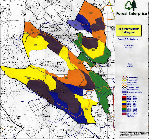
Felling plans map 2.7Mb
http://tipiglen.co.uk/screel_felling_2008.pdf
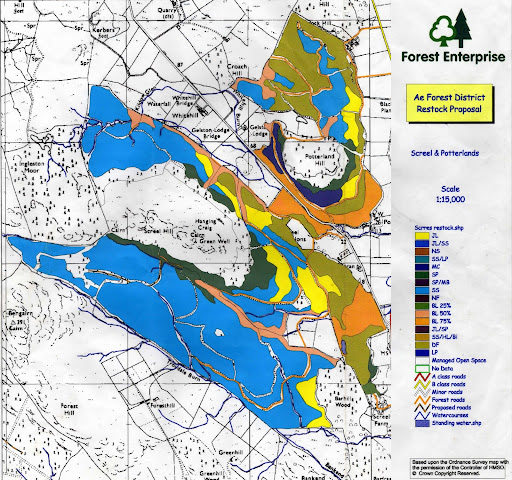
Restocking plans (What follows felling) map 2.8Mb
http://tipiglen.co.uk/screel_restock_2008.pdf
Current Thinnings:
The upcoming 2009/10 thinning:
and the area involved:
In response to a 1980 select committee which recommended that ancient woods should be recognised and treated as a separate category, the NCCs compiled the Inventories of Ancient, Long-established and Semi-natural woodlands. A more sophisticated classification was developed for woodlands in Scotland due to the nature of the available historical sources. IMPORTANT. For Scottish woods, the category Ancient' comprises woods recorded as being of semi-natural origin on EITHER the 1750 Roy maps OR the 1st Edition Ordnance Survey maps of 1860. This is due a) to the likelihood of the latter having been omitted from the Roy maps and b) to render the Scottish classification compatible with that for England and Wales. Further information on the Inventory can be found in Information and Advisory Notice 95
Dataset reference date October 2000
© Crown copyright. All rights reserved Scottish Natural Heritage 100017908 2008.

 |
|
Slideshow 1797 - 2009 |
Kirkcudbrightshire and Wigtownshire.
by William Learmonth
Read online:
Published in 1920, Univ. Press (Cambridge)
Full text:
Scottish Natural Heritage - Landscape Formation in Scotland
Canadian Forestry Corps -
a short film:
And a brief web page:
And a complete report:
Forestry Commission Plans for the Screel and Potterland Forests:
Present plans (as of 2009):
http://tipiglen.co.uk/Screel_Brief.pdf
"Executive Summary" 21Kb
http://tipiglen.co.uk/screel_concept_2008.pdf
Concept map with notes 2.2Mb
http://tipiglen.co.uk/Screel_FDP_text.pdf
Forest Design Plan 131Kb
http://tipiglen.co.uk/screel_felling_2008.pdf
Felling plans map 2.7Mb
http://tipiglen.co.uk/screel_restock_2008.pdf
Restocking plans (What follows felling) map 2.8Mb
Current Thinnings:
Thinnings 2009/10
Area involved in 2009/10 thinnings
And some older plans:
Area Felling Plans (as of 2001)
Area Re-stocking Plans (as of 2001)
And some background information on restoration of Plantations on Ancient Woodland Sites (PAWS)
Scottish Forestry Strategy Papers
Scottish Forestry Strategy (2006)
Scottish Forestry Strategy Implementation Plan 2009 - 2012
Forestry Commission History:
http://www.forestry.gov.uk/forestry/CMON-4UUM6R
And, according to the National Archives:
http://www.ndad.nationalarchives.gov.uk/AH/3/detail.html
Return to North Glen or Reading List or Credo
